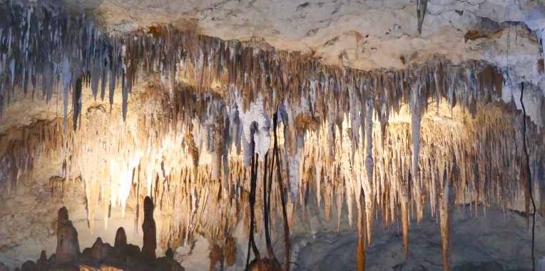
The Leeuwin-Naturaliste National Park is literally riddled with caves, and perhaps the jewel in the crown from amongst them is the aptly named, Jewel Cave. Located just off of Cave’s Road at the Augusta end, Jewel Cave is the biggest of the show caves in Western Australia, comprising of three massive chambers on display.
Fully guided one hour tours are available.
Entering the cave was an almost surreal experience as we were met with an underground wonderland of some of nature’s finest and most dazzling displays.
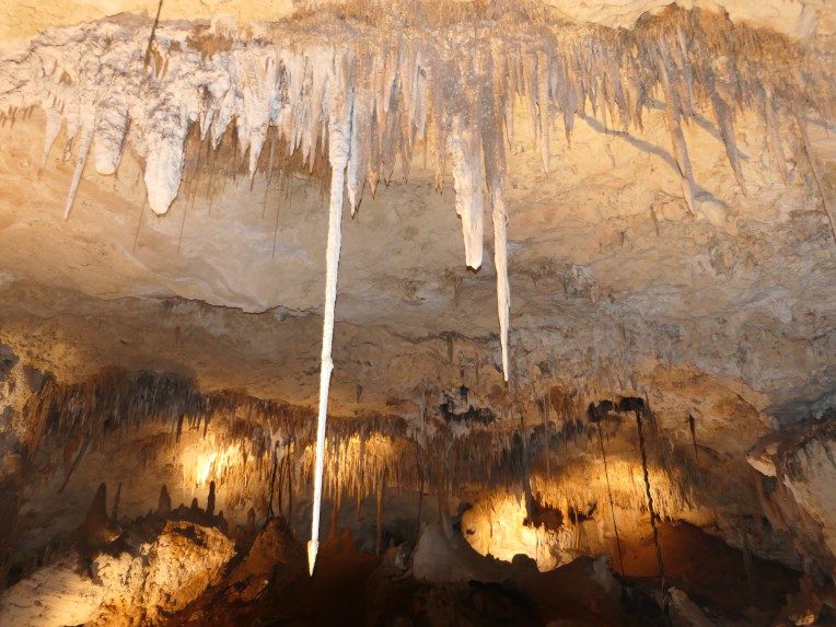
Stalactites coming down from the cave ceilingHome to one of the longest straw stalactites in Australia
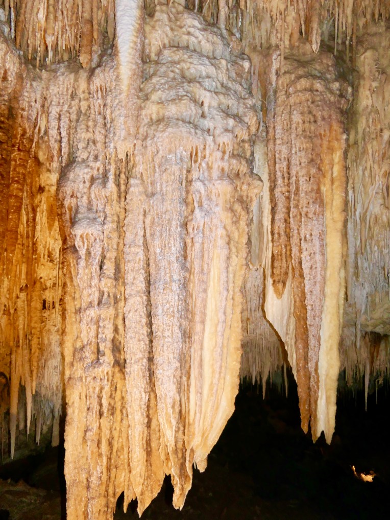
EnchantingmagicalLike flowing honey.Organ pipesThe pure white
And the pinks, and creams….
It was stunning.
The tour guide explained how the stalactites and stalagmites form, and provided quite a bit of relevant information. I, though, remained awe-struck throughout, and quite honestly to have absorbed the technical information would have taken away from the fairy-tale experience.
In the words of Lex Bastion (walkabout 1958) – Like all great works of art, nature had done her job slowly. Jewel Cave, created naturally and slowly over many thousands of years, is indeed a work of art. Nature at it’s finest, it is glorious!
The cape to cape walk follows the Leeuwin/Naturaliste Ridge for approximately 135kms. It starts near to Dunsborough and finishes at Augusta in WA’s South West. To walk the full length end to end will take between 5 – 8 days depending on fitness level, and how long you plan to walk each day. Some of the walk is definitely easy, and in parts, even suitable for wheelchairs and prams. Some of it is more difficult with a grading of level 4 and therefore only recommended for experienced bushwalkers. If you like walking, and love spectacular coastal and forest scenery, then this walk is worth putting on your list.
The Naturaliste lighthouse
On Easter Monday we decided we’d make a start on the walk, and what better place to start than at the very beginning, at the Cape Naturaliste Lighthouse. It was warmer than we’d thought, and the beginning of the track was quite exposed with no trees. We hadn’t taken water, as we only planned on a short walk, but we had planned to walk a little further than we actually did. A good reminder to observe the first rule of being in the WA bush – carry water. We’ve since ordered water bottles that can be carried in a convenient waist belt. We’ll prepare for a longer walk next time.
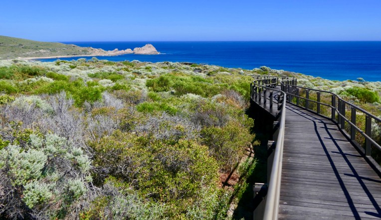
If we had taken water the first 3.8 kilometres (plus the same in return) from the lighthouse to sugarloaf rock would have been a breeze. This first section is definitely all wheelchair and pram friendly, and includes boardwalks in sections that would otherwise be a bit tougher.
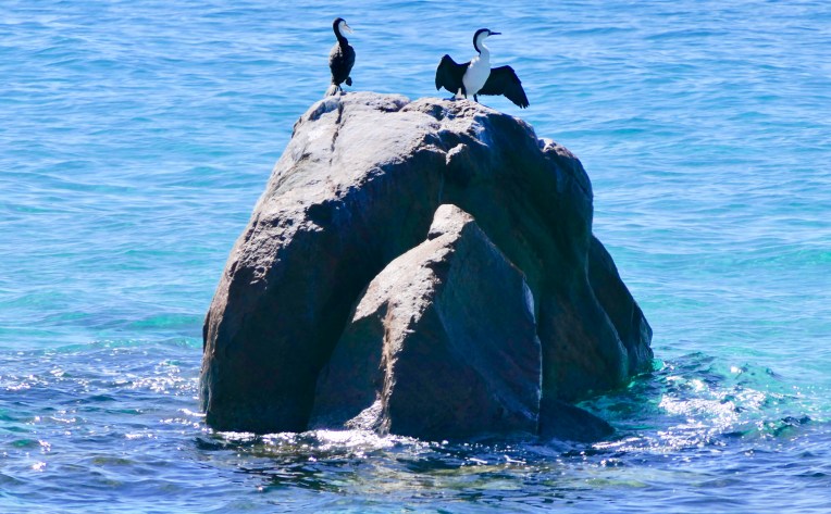
Boardwalks in the first section of the walk allowing wheelchair accessA cormorant drying it’s wings to watch on the way
One of our friends completed the full Cape to Cape last year. He whittled away at it, section by section whenever a spare day gave him the time, posting some incredible photos on face book after each section. He definitely wet my appetite to give it a go, and I’d love to complete the whole walk in the same way – day walks. Section by section whenever time and weather allows, and coming home to my own bed after each days walking. I’m keen to get started beyond the wheelchair friendly beginning, but whether or not I’m capable of doing the soft sand sections remains to be seen.
I love beach walking on firm sand, but soft beach sand is hard work. From past experience, some of the grade 4 sections of this walk include several kilometres along the beach in soft, deep sand. I think I’ll manage most of the forest sections of the track okay, and once those parts are out of the way, perhaps I’ll just have to do the harder bits – just to be able to tick the whole track off my list.
For those of you who want to do the track end to end camping along the way, there are places to stay. There’s four campsites with pit toilets and rain water tanks spaced along the track, which are only accessible by hikers. There’s also drive in camp spots at Conto’s, Point Road, and Boranyup Forest, as well as privately owned caravan parks along the way. You can either pitch your hiking tent, or perhaps hire one of their self contained cabins in the caravan parks for a sleep in a real bed.
With our summer now over and the cooler autumn weather on the way, it’s perfect for bushwalking. Watch this space for some more photos and information on the track as we tackle some of the sections in the coming weeks.
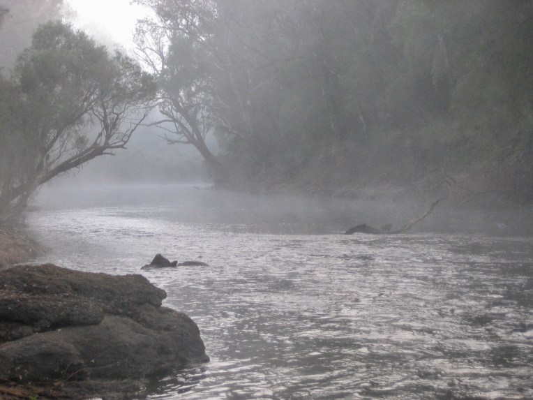
I love this place. Located in the Margaret River area, the easiest way to get to it if you’re heading south from Perth, is to look for Sues Road off the Bussell Highway as you’re nearing Busselton. The Blackwood river is the largest river in Australia’s south west and runs nearby. Walk tracks will lead you from the campground to the river. It’s a great place for launching a canoe I believe, or as we found out on our last camp trip there, a great place to watch the mist rising over the water on an early chilly, June morning.
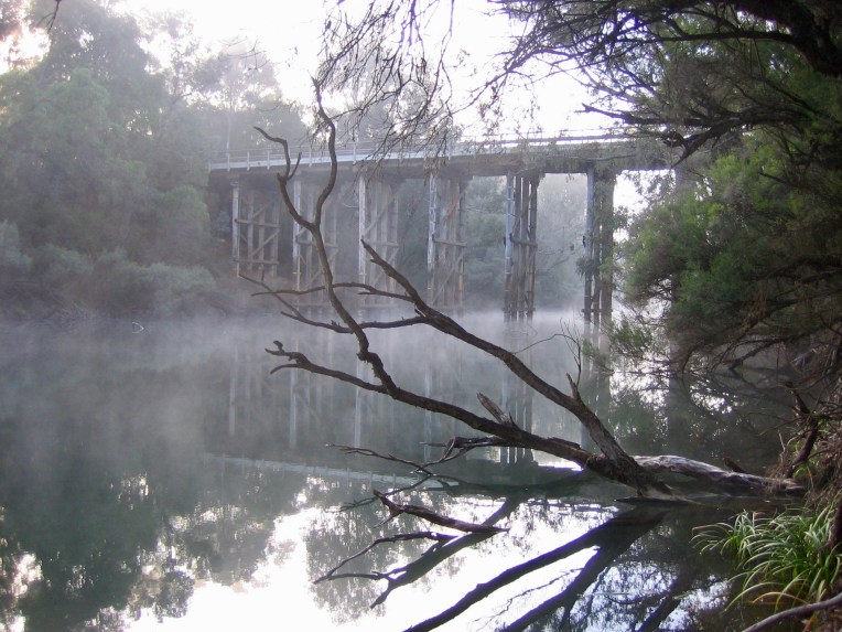
A misty morning on our last camping trip hereSue’s bridge visible as the mist lifts
It’s many years since we last camped there, and with our new caravan soon to be here, we thought we’d check it out again to see if it is worth putting on our list as a possible place for Mr Tilly’s first caravan/camping experience. I’m pleased to say it’s as good as I remember it for sure, and is definitely a strong contender.
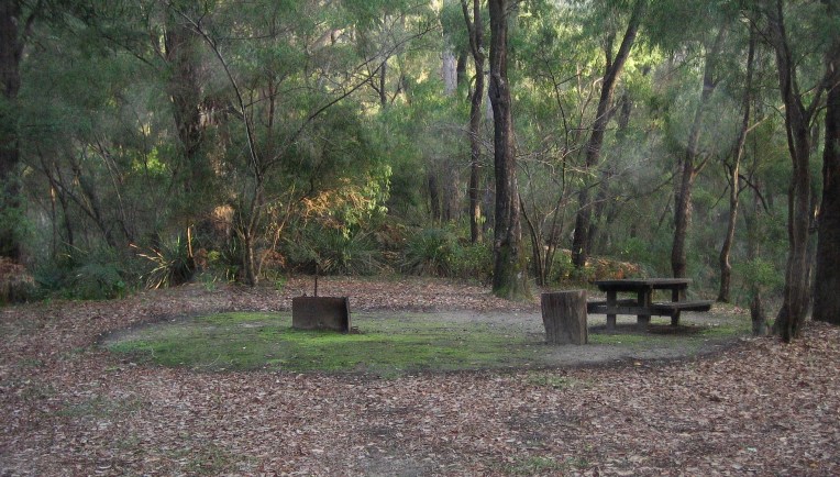
There’s 25 individual camp sites with nine of them being of a suitable size for small to mid sized caravans or camper trailers, and the other 14 being more suited to tents. There is no power, no showers, and only drop toilets. Centrally located in the camp ground is a small camper’s kitchen with sinks serviced by rainwater tanks, gas barbecues, and picnic tables. Whenever we’ve been there, it’s always been clean and well maintained.
Our camping accommodation in pre-caravan days
Each campsite has a picnic table and a fire ring. However, currently there is a total fire ban, in place, which runs from 30 November until 15 April. Campers can still cook on their own gas fuelled barbecues or camp stoves when the fire ban is in place. If you’re visiting when fires are allowed, please bring your own wood as it’s illegal to gather wood from the forest. I think the cost for camping is $11 per person per night, with an honour box system for payment (plus the ranger visits regularly). The usual concession cards are applicable to reduce your costs even further.
Gorgeous, individual camping areasGreat for cold weather campingOur friend Wendy making use of one the strategically placed logs
Bookings cannot be made, so on long week-ends or during school holiday times it pays to get in early. Dogs are welcome, but must be kept on a leash at all times. Please note: 1080 poison is used in the vicinity so it’s important to keep your four legged friend close at all times. Whilst the baits aren’t dropped in the camping area, there is always the small chance that a bird could pick one up and drop it. Keep your eyes peeled, they usually resemble a small sausage – don’t let your pets eat anything here that you haven’t provided. 1080 is fatal, and has no antidote.
On our visit this week it was almost deserted. We enjoyed our picnic lunch with Mr Tilly, soaking up the unequalled peace and ambience of the forest. I have to say, I’m getting impatient now for the arrival of the caravan. I can’t wait to take Tills here, and sit with him under the stars on a cool night in front of his first campfire. It’s going to be such a pleasure to see him expanded his horizons to include camping delights.
Last week we took a picnic lunch to Castle Bay in the Meelup Regional Park, wetting our appetites for more. More of the park that is, not the picnic lunch…..We did still take a simple little picnic with us again today though. In fact we’ve decided to make Monday a picnic day for Paul and I to have somewhere in the great outdoors. We’ll use the days to visit some of the places in the South West where dogs aren’t allowed to go. Mr Tilly gets out and about quite a lot, so a trip out for us once a week without him isn’t going to do him any harm, and I’m sure it’ll do us a lot of good.
We had a bit of a sample walk along the track from Castle Bay towards Meelup last week, however, my ankle at that time felt a little to fragile to go very far, so it was just a taster. A week later and I’m itching to get hiking. What better place to start getting serious about walking again than to pick up from where we were last week.
Wildlife safe from prohibited dogs
We again headed to the Meelup Regional Park. The park is classified as an A class reserve that stretches along the coast from Dunsborough to Bunker Bay. Approximately 600 hectares in size it’s similar in size to Kings Park in Perth. To protect the wild life, dogs are prohibited, so a good place for us to be on our Mr Tilly free Mondays. There’s plenty of walking tracks between the different Bays, so you’re sure to be reading a bit about a few of them as we get ourselves out and about.
We started at Meelup Beach today with the intentions of walking the full return distance to Castle Bay (2.4 kms in total – not far I agree, but I am still being cautious as my ankle returns to normal mobility and strength).
Meelup Beach is definitely one of the most popular family beaches in the south west. It’s a small bay with a white sandy bottom, and the water is usually gentle for toddlers that want to play in the shallows. For the older visitors there’s canoes, paddle boards, and beach games available for hire.
Meelup Beach
The shore is dotted with plenty of old trees providing shade for picnicking under, and picnic tables are abundant.
Shady picnic tablesCivilised toilet blocks
The toilet block is in keeping with the rustic surroundings, and have cold water showers, and flush toilets. Compared to the drop toilets at some of the other bays in the regional park, Meelup is quite civilised.
We arrived in time to see a pod of dolphins frolicking just out from shore. The pod were heading towards Castle Bay, as were we. They kept a similar pace to us all the way and whenever there was a gap in the trees we could see them just off shore.
Dolphins accompanying us all the way
With my ankle well supported in hiking boots and my bush stick for added stability, the 1.2 kms was easy enough, so we went the 700metres extra that took us past Castle Bay and right up to the actual Rock. Up close it’s massive.
Castle Rock up close
The track was an easy walk, but not shaded all the way. Be sure to cover up suitably against the sun, and take some water.
Only parts of the track are shaded
Then from the rock it was 1.9kms back to Meelup where we enjoyed our cheese and salad rolls with a refreshing sparkling mineral water as a Kookaburra watched on from a neighbouring tree.
Kookaburra sitting in the old gum tree
I love our South West. What a pleasure it is to live here!
Not to be confused with Castle Rock in the Porongurups, there’s also a Castle Rock just north of Dunsborough in the Meelup Regional Park.
Castle Rock framing the bay to the East
With it’s turquoise waters, white sand and several picnic tables and barbecues overlooking the beach, it makes an ideal place to enjoy a bite of lunch.
A lovely spot to sit and eat lunchThe locals stopped by for a chat and to see if we had anything on offer for them
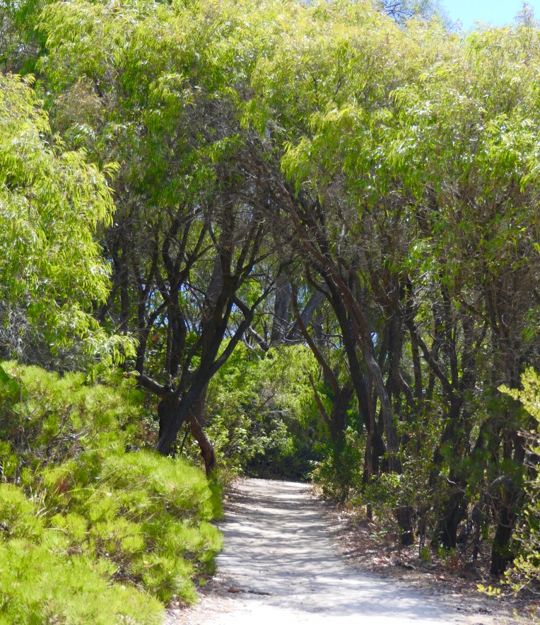
There’s walk tracks near by, including a short 1.2 km track that will take you to one of the most popular beaches in the South West, Meelup Beach. With plenty of photo opportunities on offer as you walk it could take you a while.
An inviting track leading towards Meelup BeachAn interesting rock along the path
If you’re feeling particularly energetic and agile, I believe you can also climb Castle Rock, although I’ve never attempted it myself. One day I might give it a go, I’m sure the views from the top would be amazing.
If the weather’s warm the bay provides a lovely spot for a swim and a cool off, and I’m certain there’d be lots to see if you fancied a bit of snorkelling too. There’s plenty here to keep you occupied for a few hours, so a place worthy of putting on your list should you be visiting the South West of WA. I’m lucky enough to live near by, so this place is somewhere that even the locals like me take the opportunity to visit several times a season. What a pleasure!
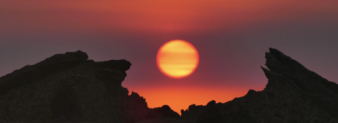
Sugarloaf Rock is one of the south west region’s most spectacular coastal land formations. It’s not hard to see why it’s one the hallmark images of renowned Australian Landscape photographer, Christian Fletcher, or why it’s graced the cover of Australian Geographic magazine. If it’s not at the top of the list of any landscape, or would be landscape photographers who visit the area, it should be.
I’m told the sea-sculptured rock is spectacular to see when the weather is stormy with the seas crashing all around. I’m also told that one of the greatest sights is to see the sun sinking over the horizon, changing the colour of the rock continuously as it sets into the Indian Ocean. Or you can see it as we did this week, on a calm, sunny day, surrounded by crystal clear waters. (Reminder to myself – visit again in stormy weather).
Situated within the Leeuwin-Naturaliste National Park, the gigantic towering granite rock emerges from the ocean, very close to shore, but completely surrounded by water. The best place to view it is from the purpose built viewing platform. Although it would be easy to wade or swim over to the rock and attempt to clamber onto it – Please don’t. The rock is a haven for nesting sea birds, including the red-tailed tropic bird from September to February.
To get to the Rock by car, leaving from Dunsborough drive along Cape Naturaliste Road for approximately 10km. Then turn left onto Sugarloaf Road. The narrow, winding road ends after three kilometres at the car parking area for the rock.
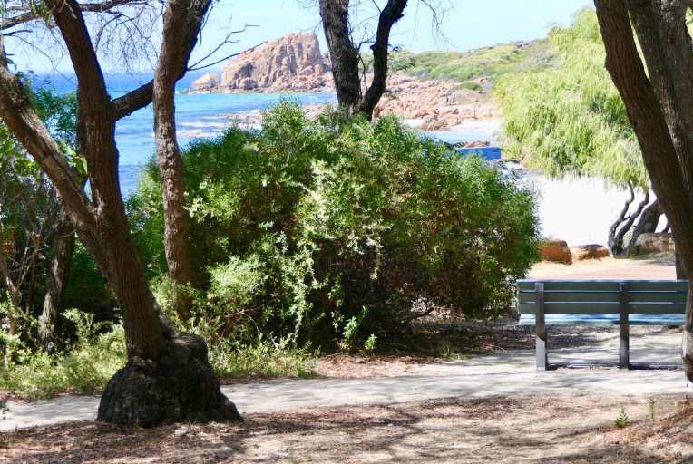
Or you could walk. Three kilometres to the north is Cape Naturaliste Lighthouse where the 140 kilometre Cape to Cape walk track commences. The first few kilometres of the track offers great views of Sugarloaf Rock, and is wheelchair and pram accessible. There’s stunning surf and beautiful bays to look down on to one side of you, and native Australian coastal bush full of birds and wildlife on the other. I’m told there’s benches conveniently place along the way to allow walkers to sit for a while to drink in the stunning vista’s or to just listen to the peace – Only a few more weeks and my ankle should be sufficiently healed to allow me to see for myself……. Still small steps though at the moment, in fact only about twenty of them to take me from the car park to the viewing platform.
What a pleasure it is to be getting out and about again.
The moon boots off, and I’m starting to get out and about again. Still a way from walking marathons, or even kilometres for that matter, but walking from a car park to a cafe is definitely welcome and do-able now.
Last week we packed what we needed for a few hours out and about with Mr Tilly. When heading out with Tills, the days of donning a hat and tucking a credit card in our back pocket are long gone. Now it’s check first if a place is dog friendly. Once that’s sorted, then make sure the dog blanket is secured in the back of the car, fill our pockets with dog treats, top up the doggie water bottle, check we have enough poo bags (sometimes up to three may be needed), and of course, our own hats, and a credit card.
The Dampier peninsula stretches approximately 220 kilometres north from Broome. At the northern most tip lies Cape Leveque, and the Kooljiman Resort/camp ground. At this stage you’ll need a four wheel drive with good clearance to get there, but there has been on-going rumours that the road is soon to be sealed. (Those rumours have abounded since we first went in 2010 – the road remains the same).
We had the good fortune to include a trip to Cape Leveque in 2010. There’s various places to stay on the peninsula, but as the Kooljiman Resort is right at the tip, it offers easy access to both the rising sun from the east, and the setting sun from the west. It’s an ideal location to see just how good the sun can be at different times of day.
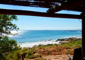
Looking out to the right from our beach shelter
For our stay we rented a three sided beach shelter on the eastern side. We had our camper trailer at the time, and parked that beside the shelter, whilst Dianne and Bob set up a small tent inside. There was a cool water shower in the corner of the shelter, and a picnic table outside overlooking the water. The loos, and hot water showers were a bit of a trek away, but we often just made do with the cool shower in our own shelter.
And to the left
From the time the sun came up in the morning, to when it set in the evening the days were filled with so much to see and do. Being on the eastern side of the peninsula we had the joy of seeing the sun rise over the ocean, something rare for those of us who live in the west of the country.
The sun beginning to light up the sky
Sometimes we’d wake to an empty ocean view, and sometimes we’d wake, green with envy, when some lucky person or two had anchored their yacht just offshore.
Yacht anchored overnight
There was always plenty to do throughout the day. The water was only a few steps from our shelter, and absolutely perfect for a dip. In case you’re wondering, crocodiles and stingers are prevalent around the Dampier peninsula, everywhere that is except at the Cape. Apparently the tides there keep them away, or so I’m told. So we swam in safety, the guys managed to throw a line in a few times, and we went for plenty of beach walks.
Cruise ship anchored offshore
When we were at the shelter there was always something happening on the water to look at. Sometimes it would be a fellow camper doing some kayak fishing, or sometimes it would be one of the small luxury cruise liners anchored up ferrying passengers in for some shore time.
And then when the sun started it’s decent it was time to head around to the western side of the peninsula. Cape Leveque is famous for it’s sunsets, but it’s not as you’d imagine. It’s not the sky that brings artists and photographers from near and far to capture the glorious spectacle as the sun drops towards the horizon. As the sun sinks towards the horizon the rays hit the orange cliffs lining the shore. They shine bright, almost as if they’re lit from inside.
Cliffs lit up by the setting sun
Yes – these colours are for real
Just another place that adds to the ‘colours of the Kimberley’, and no trip to this glorious region would be complete without a trip to the Cape.
There’s various forms of accommodation at Kooljaman ranging from camping options, either in the campground, or at one of the beach shelters. There’s also different levels of houses to rent. Check them all out long before you arrive though to make your selection, and book early. They book out early in the season.
Just another wonderful Kimberley destination to add to your bucket list…..
After witnessing the mostamazing scenery to get to Talbot Bay, we boarded the pontoon to await our pre-lunch scenic cruise. As I remember it, it was a warm and humid day. A swim would have been most welcome, but on second thoughts – nah!! At the time we visited in 2010 the staff on board the pontoon used to feed these sharks. I think that today you can swim with them, (I guess from within the safety of a shark cage). I think the swimming is done near the pontoon, so quite likely, these same fish.
No diving off the boat either
After a bit of relaxation we boarded a small motor boat for our scenic tour. A gentle cruise around some of the Islands and waterways provided a bit of background to the flora and fauna in the area.
A Rock wallaby peering out from behind some rocks
Boat seats, or should I say saddles
Then back to our base for a barramundi fish barbecue lunch before boarding our jet boat for the excursion to, and over the Horizontal Falls.There were some bench seats on the boat, but most people chose the safety of straddling a seat with a bar to hold onto. Once we entered the falls, I’m sure those of us riding bronco style appreciated the security of that hand hold. I’m pretty sure I, for one, would have been white knuckled as I hung on.
Looking back at the photos it all looks much more innocuous than it felt. In reality it was more exhilarating than any fair ground ride.
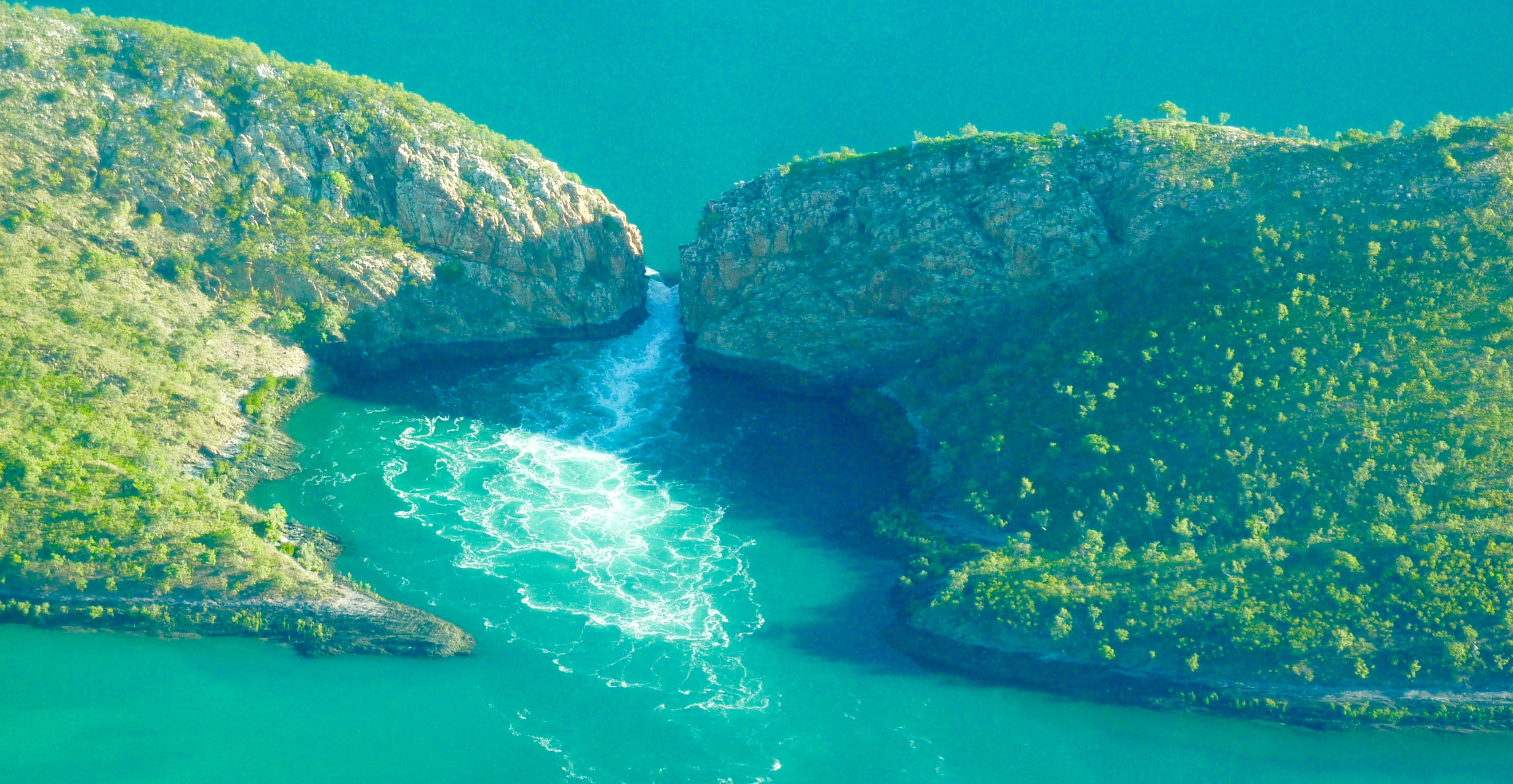
The jet boat was almost as long as the gap was wide that we were to go through. Fortunately, our skipper knew what he was doing. He lined us up, and then with all engines screaming and all of us hanging on for grim death, we shot full throttle upwards towards the horizontally, tumbling waters.
Entering the falls
about mid way
and then the final ascent
The falls receding behind us
Looking back the tranquility defies the reality of what we’d just experienced
We went back for another go, and a third, and maybe even a fourth. One things for sure, we couldn’t get enough of it.
Then back to the pontoon to board our seaplane for the return trip to Broome. Looking down on the falls on our departure it was hard to imagine the sheer force of the water. It looked so tame…
The falls again from the air on our departure
And that was our trip to the Horizontal Falls, now almost eight years ago. It was then, and remains so today the absolutely best travel experience we’ve ever had. Would we do it again? – I don’t know. I’m always a little weary of repeating something that’s provided an amazing memory. What if it isn’t as good as I remembered it, then the memory would be spoilt for ever more. So, much as I’d love to, and want to, I don’t know if I should.
We did the full day tour. The cost today for that tour is around $1000 (give or take a little bit). The half day tour (approximately 6 hours in total) is a little bit cheaper, and there’s an overnight option for a little bit more. For the overnight option, as I remember it, the pontoon has ensuite cabins on board. The overnighters usually get to experience going over the falls in both directions, using both the incoming, and outgoing tides.
Then there’s also a 4 night trip at the cost of around $4000. This option incorporates some fishing and some pristine swimming holes away from the dangers of the crocs. I’m sure, there would be some spectacular scenery on offer cruising round the archipelago. If I was tempted into doing it again – I think this is the option I’d have to chose, just so as it incorporated a little more than before.But, as I’ve already seen both the archipelago from the air, and experienced the amazing Horizontal Falls, perhaps I’ll save the money for a completely new experience, a completely new pleasure!
If you haven’t already done the falls, the half day excursion is all you need to put something absolutely amazing into your own book of life. If you include anything extra, whilst enjoyable no doubt, in reality I’m sure it’ll only be providing background to the shining star – The Horizontal Falls.
This is an absolute Bucket List destination. For both Paul and I, it surpassed swimming with the whale sharks off Ningaloo Reef, and it surpassed our amazing glamping sojourn last year to the Mitchell Plateau and falls. Those two things, whilst both being absolutely stand out experiences, pale in comparison to The Horizontal Falls. Photos, nor relating the experience can come close to letting you live the experience vicariously. It’s something you have to do for yourself to appreciate it. So, if you haven’t already done this, and if it’s at all possible, please put this excursion high up on your bucket list, and make sure you tick it off. You won’t regret it.